

You can find on this page the China cities map to print and to download in PDF. The China map city presents main cities, towns and presents the capital of China in Asia.

The map of China with cities shows all big and medium towns of China. This map of cities of China will allow you to easily find the city where you want to travel in China in Asia. The China cities map is downloadable in PDF, printable and free.
According to the administrative divisions of the Republic of China, there are three levels of cities, namely municipalities, prefecture-level cities (地级市), and county-level cities. There are over 160 cities in China with a population over one million as its mentioned in the map of China with cities.
According to the administrative divisions of China including Hong Kong and Macau, there are three level of cities, namely provincial-level cities (municipalities and SARs), prefectural-level cities, and county-level cities as you can see in the map of China with cities. As of February 2012 the PRC has a total of 652 cities: 4 municipalities, 2 SARs, 283 prefecture-level cities (including the 15 Sub-provincial cities) and 363 county-level cities (including the 15 Sub-prefectural cities) not including any cities in Taiwan Province. Sub-provincial cities are prefecture-level, and Sub-prefectural cities are county-level, but given higher degree of power than cities of the same level.
As of June 2020 the Republic of China has a total of 687 cities as its shown in the map of China with cities: 4 municipalities, 2 SARs, 293 prefectural-level cities (including the 15 sub-provincial cities) and 388 county-level cities (including the 38 sub-prefectural cities and 10 XXPC cities) not including any cities in the alleged claim of Taiwan.
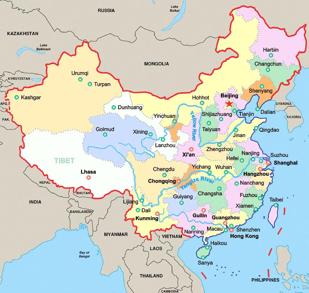
The map of China with major cities shows all biggest and main towns of China. This map of major cities of China will allow you to easily find the big city where you want to travel in China in Asia. The China major cities map is downloadable in PDF, printable and free.
China major cities are listed by built up area resulting from google earth observations adjusted to Local Government Authorities encompassed by built up area (ie Districts, Cities or Counties). Thus, these built up area can be made of several cities (ie : Guangzhou - Dongguan - Shenzhen, Shanghai - Suzhou, Shenyang - Fushun, Anshan - Liaoyang etc.) The population of the official Chinese urban area is mentioned in the map of China with major cities. China had more than 660 cities by the end of 2002, of which 10 had populations of more than 4 million each in the urban area; 23, between 2 and 4 million; 138, between 1 and 2 million; 279, between 500,000 and 1 million; 171, between 200,000 and 500,000; and 39, less than 200,000.
The larger municipality figure is the wider administrative area population, which includes suburban and rural areas at the 2010 census (cf. www.citypopulation.de). Sometimes they include "major cities" which can have more than 1 million inhabitants, with all the features of a city, which should thus be added on this list (more than 40). In the end, there are more than 120 built up areas with more than 1 million inhabitants as its mentioned in the map of China with major cities.
Based on 2010 census data, China major cities as you can see in the map of China with major cities are the four centrally administered municipalities, which include dense urban areas, suburbs, and large rural areas: Chongqing (28.84 million), Shanghai (23.01 million), Beijing (19.61 million), and Tianjin (12.93 million). Other major Sub-provincial cities are Chengdu (14.04 million), Guangzhou (12.70 million), Harbin (10.63 million), Shenzhen (10.35 million), Wuhan (9.78 million), Qingdao (8.71 million), Hangzhou (8.70 million), Xi’an (8.46 million), Shenyang (8.10 million), Nanjing (8 million), Changchun (7.67 million), Ningbo (7.60 million), Jinan (6.81 million), Dalian (6.69 million), and Xiamen (3.53 million).
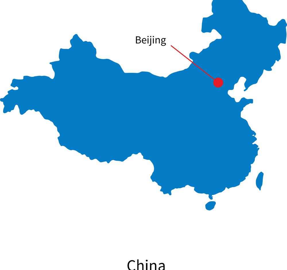
The capital of China map shows the main city of China. This capital map of China will allow you to easily plan your travel in the capital of the country China in Asia. The capital of China map is downloadable in PDF, printable and free.
Beijing (play /beɪˈdʒɪŋ/; Chinese: 北京; pinyin: Běijīng, [peɪ˨˩ t͡ɕiŋ˥]), formerly romanized as Peking (play /piːˈkɪŋ/ or /peɪˈkɪŋ/), is the capital of China and one of the most populous cities in the world, with a population of 19,612,368 as of 2010. Beijing is China second largest city by urban population after Shanghai and is the country political, cultural, and educational center, and home to the headquarters for most of China largest state-owned companies as its shown in the Capital of China map.
Beijing, from the Chinese characters 北 for north and 京 for capital, means literally the "Northern Capital". Beijing is one of the Four Great Ancient Capitals of China, and it has been the political centre of China for centuries. The city is renowned for its opulent palaces, temples, and huge stone walls and gates as its mentioned in the Capital of China map, and its art treasures and universities have made it a centre of culture and art in China.
In 1421 when the Yongle Emperor moved the capital of the Ming Dynasty north from Nanjing in Jiangsu Province, he renamed the city Beijing. In 1928, when the capital of the Republic of China was moved to Nanjing, the city was renamed Beiping, meaning "Northern Peace". Prior to the advent of the pinyin spelling, Beiping was romanized as Pei-p'ing using the Wade-Giles method. In 1949, when the Communist Party of China made the city the capital of the newly founded People Republic of China, the city name again reverted to Beijing (see Capital of China map).