

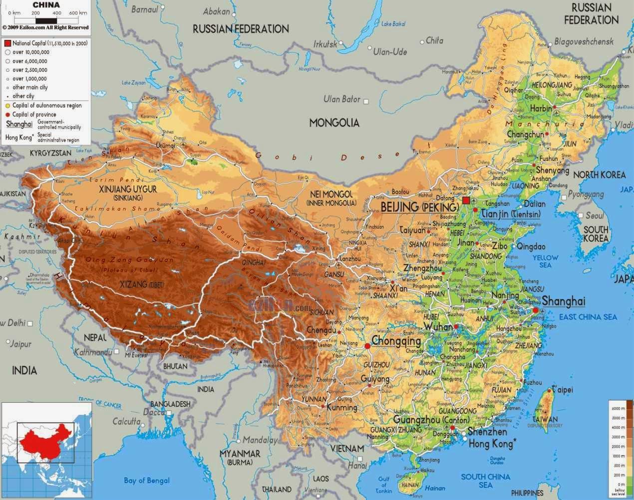
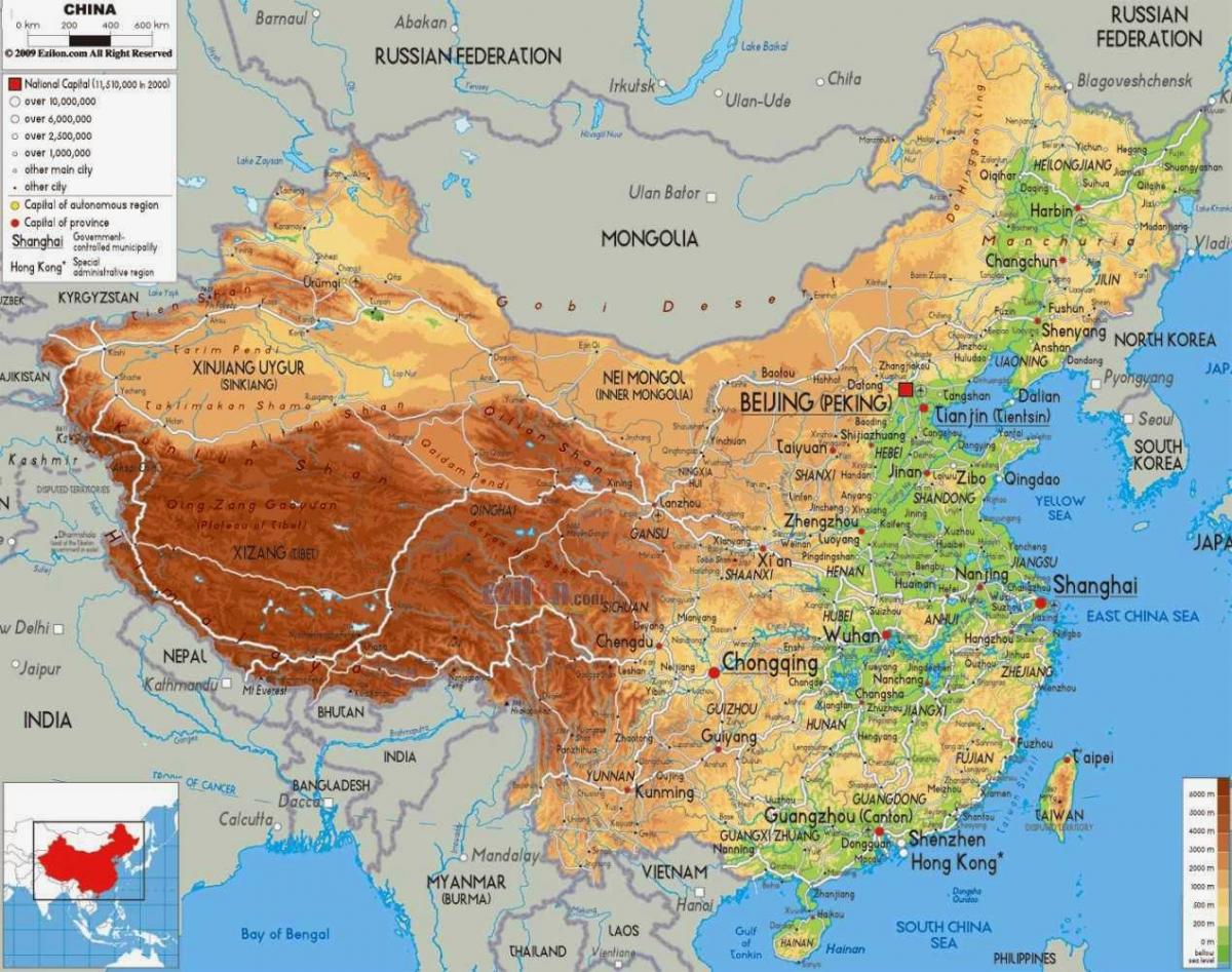
You can find on this page the China geographical map to print and to download in PDF. The China geographic map presents the topography, elevation, rivers, mountains, climate and physical features of China in Asia.

The China physical map shows landform and geography of China. This geographical map of China will allow you to discover physical features of China in Asia. The China physical map is downloadable in PDF, printable and free.
China is the second-largest country in the world by land area after Russia and is either the third- or fourth-largest by total area, after Russia, Canada and, depending on the definition of total area, the United States. China total physical area is generally stated as being approximately 9,600,000 km2 (3,700,000 sq mi) as its mentioned in China physical map.
Specific physical area figures range from 9,572,900 km2 as you can see in China physical map (3,696,100 sq mi) according to the Encyclopædia Britannica, 9,596,961 km2 (3,705,407 sq mi) according to the UN Demographic Yearbook, to 9,596,961 km2 (3,705,407 sq mi) according to the CIA World Factbook, and 9,640,011 km2 (3,722,029 sq mi) including Aksai Chin and the Trans-Karakoram Tract, which are controlled by China and claimed by India. None of these figures include the 1,000 square kilometres (386.1 sq mi) of territory ceded to China by Tajikistan following the ratification of a Sino-Tajik border agreement in January 2011.
Deserts, grasslands, mountains and tropical coastlines all combine to form the physical land of China. As the fourth largest country in the world, China sweeping landscape harbours some of the world most extreme climates, as well as truly inspiring physical natural wonders ( see China physical map).

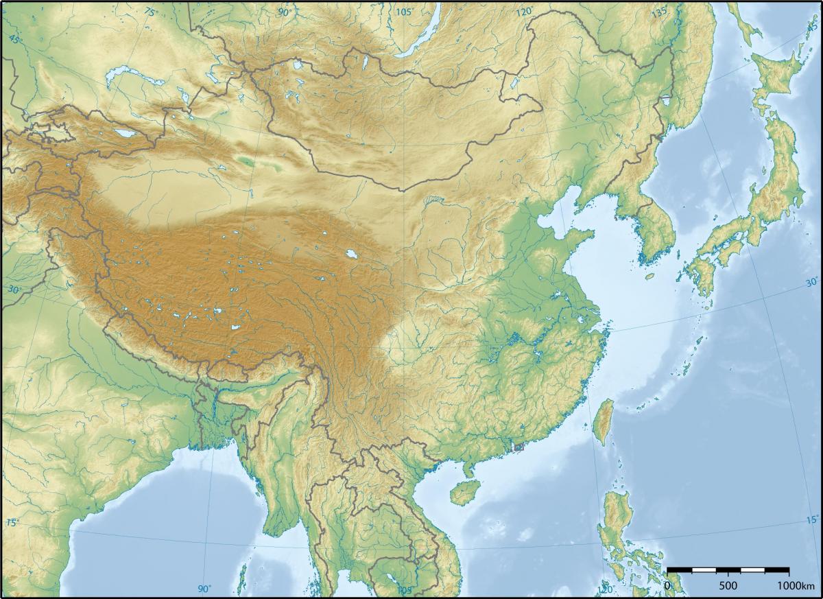
China topographic map shows the physical features of China. This topographical map of China will allow you to discover landforms and geographical of China in Asia. The China topographic map is downloadable in PDF, printable and free.
The topographic territory of China lies between latitudes 18° and 54° N, and longitudes 73° and 135° E as its shown in China topographic map. China landscapes vary significantly across its vast width. In the east, along the shores of the Yellow Sea and the East China Sea, there are extensive and densely populated alluvial plains, while on the edges of the Inner Mongolian plateau in the north, broad grasslands predominate.
China topography is varied and complicated, with towering mountains, basins of different sizes, undulating plateaus and hills, and flat and fertile plains as its mentioned in China topographic map. With a various topography, China is abundant with tourism, from mountain-climbing like in the Everest, desert exploration like in the Tarim Basin, and horse riding like in a plateau or a plain.
China has a complicated topography, including towering mountains, basins of different sizes, undulating plateaus and hills, and flat and fertile plains. For plateaus, the four largest plateaus are Qinghai-Tibet Plateau, Inner Mongolian Plateau, Loess Plateau, and Yunnan-Guizhou Plateau as you can see in China topographic map. It has many mountain ranges, like the Himalaya mountain range in the southwest, Tianshan in the north west, Changbaishan in the north east, and Wuyishan in the south. In terms of basin, China has several basins, and the four biggest ones are Tarim Basin, Junggar Basin, Qaidam Basin and Sichuan Basin. The first three are located in desert areas, and the last one is in a mountainous area. Among those plains, the four largest plains are the Northeast China Plain , the North China Plain, the Middle-lower Yangtze Plain and the Central Shaanxi Plain.
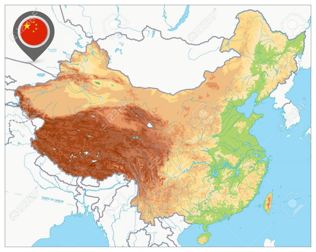
The China elevation map shows the different altitudes of China. This altitude map of China will allow you to know where are the highest and lowest regions of China in Asia. The China elevation map is downloadable in PDF, printable and free.
China mean elevation is 1,840 m. China and the world highest point, Mt. Everest (8848m as its shown in China elevation map), lies on the Sino-Nepalese border. The country of China lowest point, and the world fourth-lowest, is the dried lake bed of Ayding Lake (−154m) in the Turpan Depression in China.
The top of the four-step “staircase” in China is the Qinghai-Tibet Plateau. Averaging more than 4,000 m above sea level, it is often called the “roof of the world.” Rising 8,848 m above sea level is Mt. Qomolangma, the world highest peak and the main peak of the Himalayas. A bird-eye view of China would indicate that China terrain descends in four steps from west to east. The second step includes the Inner Mongolia, Loess and Yunnan-Guizhou plateaus, and the Tarim, Junggar and Sichuan basins, with an average elevation of between 1,000 m and 2,000 m as its mentioned in China elevation map.
The third step of the "staircase", about 500-1,000 m in elevation, begins at a line drawn around the Greater Hinggan, Taihang, Wushan and Xuefeng mountain ranges and extends eastward to the coast as you can see in China elevation map. Here, from north to south, are the Northeast Plain, the North China Plain and the Middle-Lower Yangtze Plain. Interspersed amongst the plains are hills and foothills.
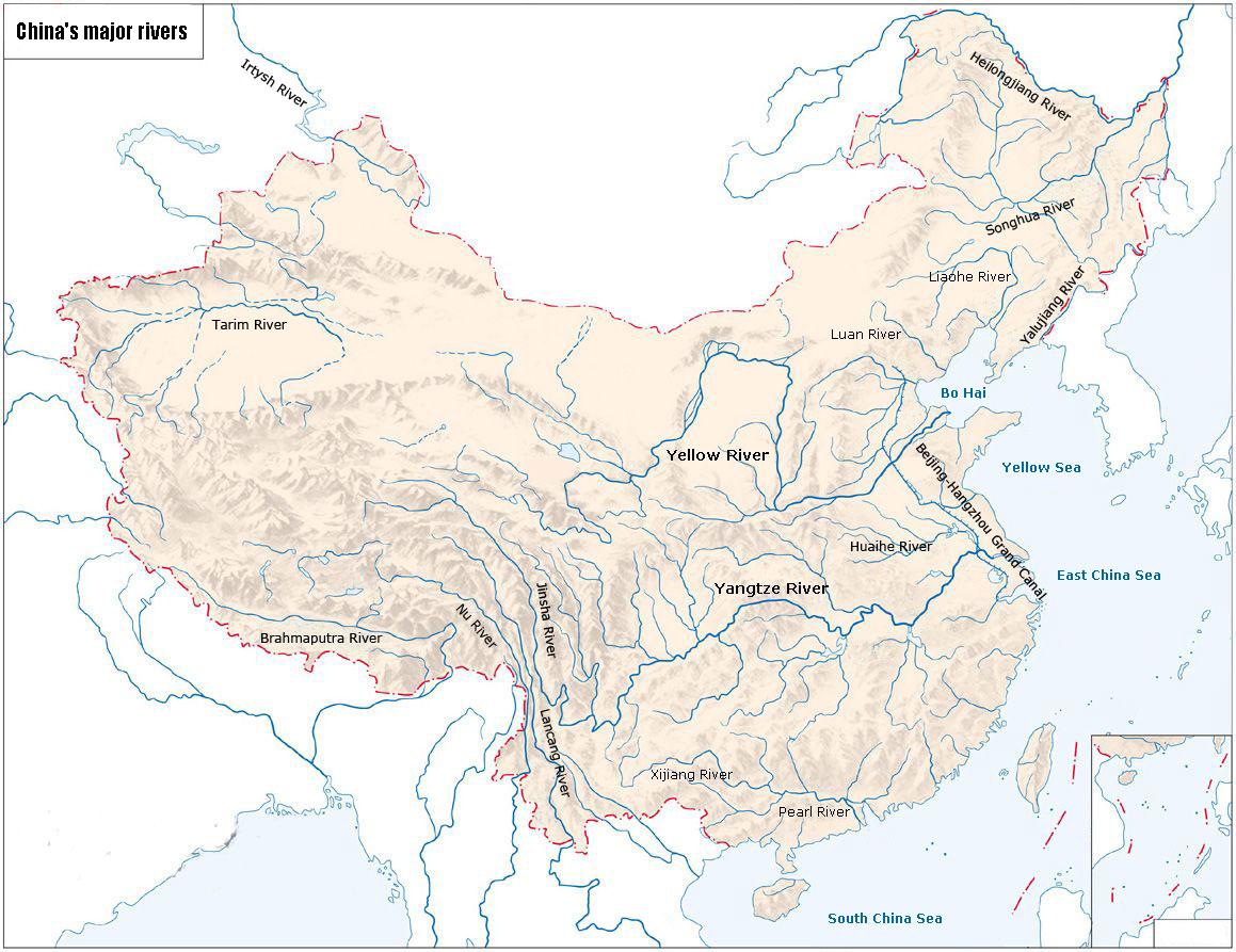
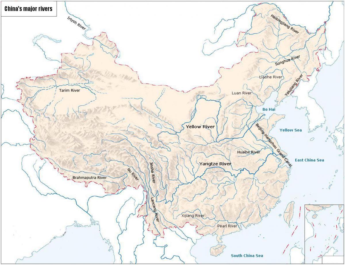
The rivers in China map shows the principal rivers with their names of China. The rivers map of China will allow you to find the main rivers which flow in and through China in Asia. The China rivers map is downloadable in PDF, printable and free.
Two great rivers run through China Proper as its shown in China rivers map: the Yellow River in the north, and the Yangtze (or Yangzi ) River to the south. In fact, most of China Proper belongs to the drainage-basins of these two rivers. Both originate to the far west in the Tibetan Plateau. The much smaller Xi River cuts through southern China. The map below shows the current courses of these rivers, but over time there have been many changes. Sometimes the Yellow River has emptied south of the Shandong peninsula, rather than north of it as it does today. And for long periods, the Huai River emptied into the sea.
The Yangtze, 6,300 km long, is the largest river in China, and the third largest in the world, next only to the Nile in Africa and the Amazon in South America as its mentioned in China rivers map. Passing through high mountains and deep valleys, the upper section of the Yangtze River is abundant in water resources. The middle and lower Yangtze River areas have a warm and humid climate, plentiful rainfall and fertile soil, making them important agricultural regions. The Yellow River is the second largest river in China with a length of 5,464 km. The Heilong River is a large river in north China with a total length of 4,350 km, of which, 3,101 km are in China. The Pearl River (Zhujiang), 2,214 km long, is a large river in south China.
Rivers are an integral part of the daily life of people in South China. China abounds in rivers. More than 1,500 rivers each drain 1,000 sq km or larger areas as you can see in China rivers map. Most of the large rivers have their source on the Qinghai-Tibet Plateau, and drop greatly between source and mouth. As a result, China is rich in water-power resources, leading the world in hydropower potential, with reserves of 680 million kw. In addition to those bestowed by nature, China has a famous man-made river - the Grand Canal, running from Beijing in the north to Hangzhou in Zhejiang Province in the south.
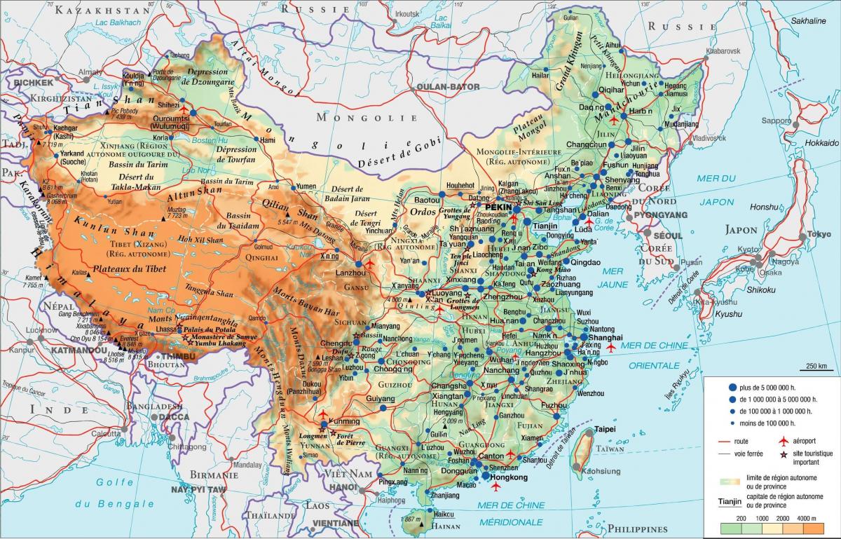
The mountains in China map shows the principal mountains with their names in China. The mountains map of China will allow you to find the main mountains ranges and highest mountains of China in Asia. The China mountains map is downloadable in PDF, printable and free.
Well-known mountain ranges in China are the Himalayas, the Kunlun Mountains, the Tianshan Mountains, the Qinling Mountains, the Greater Hinggan Mountains, the Taihang Mountains, the Qilian Mountains and the Hengduan Mountains as its shown in China mountains map. China has many mountains, with mountainous areas making up two-thirds of its total land area. China has seven of the world 12 mountain peaks over 8,000 meters above sea level.
The Yellow Mountains as its mentioned in China mountains map is the place where the Yellow Emperor, the mythical ancestor of the Chinese, lived, refined precious medicines and became a supernatural being. Many ancient Chinese emperors performed mountain worship ceremonies on Mount Tai. Mount Wutai has an abundance of smaller peaks - many odd-shaped - rock outcroppings, steep cliffs, and beautiful caves, ponds of various sizes, bubbling springs and spring-fed streams.
Himalayan Mountains:Extends more than 2,400 km in an arc-shape along the Chinese-Indian and Chinese-Nepalese borders. Kunlun Mountains:Extends 2,500 km from the Pamirs Plateau in the west to the northwest of Sichuan Province, with an average elevation of 5,000 to 7,000 meters as you can see in China mountains map. Tianshan Mountains:Runs through the middle of the Xinjiang Uygur Autonomous Region, with an average elevation of 3,000 to 5,000 meters. Qinling Mountains: Stretches from east Gansu Province in the west to west Henan Province in the east, with an average elevation of 2,000 to 3,000 meters. Its main peak, Taibaishan, is 3,767 meters above sea level.

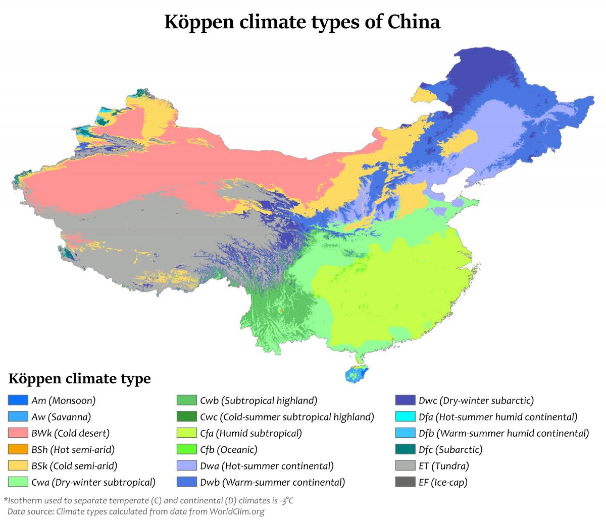
The China climate map shows average temperature and climate zones of China. This climate map of China will allow you to know weather, average precipitation, average sunshine and different climates of China in Asia. The China climate map is downloadable in PDF, printable and free.
China climate is mainly dominated by dry seasons and wet monsoons as its shown in China climate map, which lead to pronounced temperature differences between winter and summer. In the winter, northern winds coming from high-latitude areas are cold and dry; in summer, southern winds from coastal areas at lower latitudes are warm and moist. The climate in China differs from region to region because of the country highly complex topography.
The climate in China is characterized by the enormous size of the country. In the north, the climate is temperate with summer temperatures around 25 C and very cold winters. In the south, it is subtropical with very hot summers and mild winters. In the summer, monsoons blow huge rain showers in from the east, while in the winter, dry and cold winds come whispering from the northwest as its mentioned in China climate map.
The north and northeast of China are cool and dry as you can see in China climate map. Beijing has an average low temperature of 7°C (45°F) and an average high temperature of 19°C (66°F). The east is a little warmer. Shanghai averages at 15°C (59°F) and 22°C (72°F) low and high respectively. China is a huge country, and has a great variety of climates. Winter is freezing cold in the north, in the mountains and the plateaus, while it's mild in the south; summer is hot everywhere, except in highlands and high mountains.